
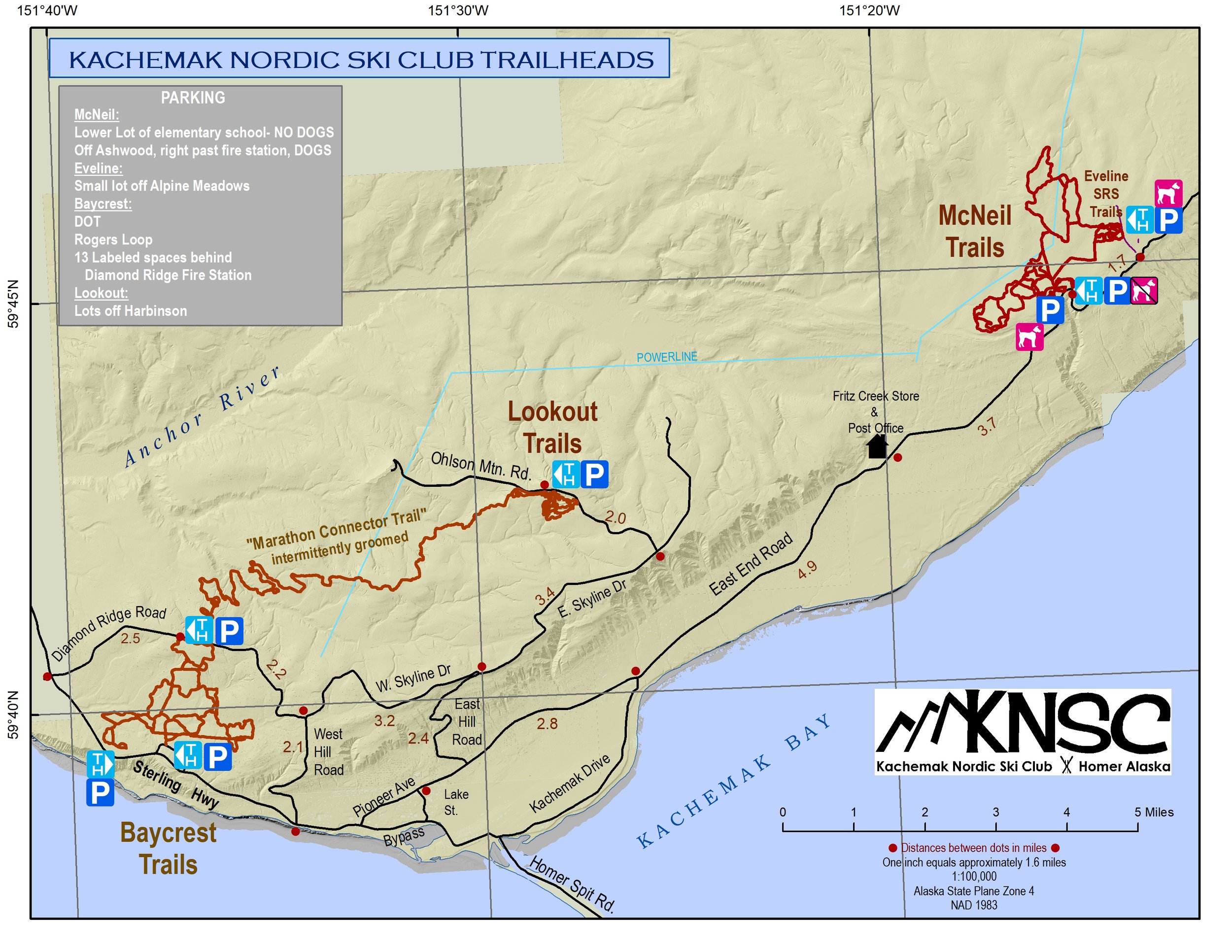
KNSC has built and maintains over 80 km of winter ski trails in the Homer area. Trails are located in three areas: Baycrest, Lookout Mountain, and McNeil/Eveline. There is also a Marathon Connector Trail that connects Baycrest and Lookout Mountain during part of the season when snow depth allows.
The Lookout Mountain system is our competitive venue suitable for school team practice, races and a variety of other scheduled events. Due to the heavy use and challenging hills, dogs are not allowed on any of the trails. The upper Baycrest Trails are on private property and no dogs are allowed there either. Lower Baycrest and the McNeil/Eveline/Wolf Ridge systems are on generally gentler terrain, and one dog per skier is allowed if there is not an event in progress. Please keep your dog under control and be mindful of the possibility of fast approaching skiers, especially near blind corners at the bottom of downhill sections. Skiers must clean up after their dogs.
In the summer, The Homestead Hiking Trail goes from the Roger’s Loop Trailhead to the Rucksack Trailhead on Diamond Ridge Road. The Homer Soil and Water Conservation District and volunteers maintain it for summer use. There is also an Arboretum and Nature Trail in the Demonstration Forest near the Rogers Loop Trailhead. At Eveline State Recreation Site there are summer trails and a picnic area. Part of the 1.5 mile loop is wheelchair accessible.
WOLF RIDGE TRAILS ~ 10 KM
The second right from the parking at the McNeil Elementary School is immediately after the first. That trail ascends 1.3 km north to connect to Wolf Ridge. Wolf Ridge has upper loops and a lower, flat loop with fun skiing through a fen straddling the divide between McNeil Creek and the Anchor Rover. The lower loop can be accessed from the Eveline SRS system, or from the upper loop. A 0.5-km connector trail at the southeastern corner of the lower fen loop hooks into the Eveline system. The upper loop climbs and descends through open meadows with hills and curves and offers views of the Kenai Mountains that are well worth the climb.
The Wolf Ridge trail is maintained through a year-to-year permit with Cook Inlet Region Inc. A condition of the permit requires users to pack out their dog waste. A short portion of the Wolf Ridge Trail are shared with snowmachines and dog teams- and other users. This shared portion is along the short connector through the willows between the powerline and the lower loop in the fen to the east. The Wolf Ridge trail system is maintained once the CIRI has approved the permit.
RAVEN’S WAY LOOP – 5 KM
The Raven’s Way Loop is accessed from the Baycrest Sterling Highway/DOT Trailhead and large parking lot. From the trailhead this loop exits the muskeg stadium to the west along the Woodcutter’s Trail. If you choose you can take the Dibble Creek Trail for a great downhill run instead. Turn right to follow the muskeg which make this trail an ideal choice for beginners or those looking to practice their skating or classical technique. Continue along Diamond Creek to an area below the Homer Garbage Transfer site. There is a chance to see lots of eagles and ravens in this area. Turn left to cross Diamond Creek and left again at the next intersection. The trail again meanders through open spruce forest and muskegs. One medium hill provides a little change of pace before the trail turns right to return to the stadium and trailhead. Most of the main loop is on the Diamond Creek Homer City Park property.
HOMESTEAD SKI LOOP – 5 KM
From the Baycrest Roger’s Loop Trailhead, the Homestead Ski Loop heads east over gently rolling terrain until it crosses Diamond Creek. From there the trail climbs steadily to an open meadow on Pitzman’s Hill. A short downhill gives a brief respite before another climb up to the intersection with Master Blaster. The trail continues west skirting the edge of the forest until it comes to a four way intersection. A small bench here invites skiers to take a break and enjoy the view of Cook Inlet, Mt. Augustine and Mt. Illiamna volcanoes. A long downhill run to Diamond Creek is a fun payback for the uphill climbs. A left behind the bailing facility then a right with a short uphill brings you back to the Roger’s Loop trailhead. The top of the Homestead Loop is on private property. Please stay on the trail while on private property.
DEMONSTRATION FOREST LOOP – 2.5 KM
The Demonstration Forest Loop also starts at the Baycrest Roger’s Loop Trailhead and meanders through the heart of the State of Alaska Homer Demonstration Forest. A few gentle ups and down in the woods add interest to this easy, mostly level trail. The 1 K Cutoff and Thru the Woods connector trails join this loop in a large muskeg about two thirds of the way around the trail. Cross Diamond Creek and a short climb takes you back to the Roger’s Loop Road trailhead. Stop by to read the signs describing THE DIAMOND CREEK PROJECT.
HEADWATERS HIGHWAY TRAIL – 6 KM
The Headwaters Highway is a challenging trail with names like Killer Hill, Stitzmark Hill and The Grand Canyon plus lots of tight turns. From the Baycrest Roger’s Loop Trailhead, follow the Homestead Ski Loop until a four-corner intersection with the 1 K Cutoff. Turning right at the intersection, this trail follows an old seismograph line up and down the hills. The Headwaters Cutoff provides an alternate route for those not wishing to venture into the Grand Canyon. In spite of the names, this really is a fun trail through the woods, which connects to the Homestead Ski Loop at Pitzman’s Hill. Heading down hill to the Demonstration Forest Loop and then returning to the Baycrest Roger’s Loop Trailhead completes approximately 6 km. This trail can also be accessed from Mountain Park and Eagle View neighborhoods. No parking is available at neighborhood access points, which are on private property. Remember to stay on the designated trails when you are on private property.
THE PERIMETER – 15 KM
By skiing the outer most portions of the Upper and Lower Baycrest trail system, it is possible to put together a 16 km loop of interesting, challenging, scenic skiing.
OTHER FUN CONNECTING TRAILS
MASTER BLASTER – This is an up and down, tight cornered romp through the woods.
COLLEGE AVENUE – A wonderful, gentle downhill glide through open meadows with a short section of woods.
ROBERT AND ROBERTA’S TRAILS – These trails are on private property but open to all skiers and snowshoers. They provide a way to avoid the Grand Canyon with open meadows and narrow trails through sections of young spruce and also provide neighborhood access for Eagle View and Mountain Park subdivisions.
1K CUTOFF – This is a short easy connector between the Homestead and the Demonstration Forest Loops.
SERPENTINE – The Serpentine connects Upper Baycrest with the Homestead Loop. It has challenging, steep, turning curves suitable for advanced skiers.
BAYCREST ROGERS LOOP MARKED SNOWSHOE TRAIL – 5 KM
When conditions allow, there is a marked snowshoe trail. It begins and ends at the Roger’s Loop Trailhead. The trail follows the summer Homestead Hiking Trail and goes up to the Ruben Call Bench where there are spectacular views. This trail needs significant snow before brush is covered and signs can be placed in the snow.

KNSC WINTER AND SUMMER TRAILS
Kachemak Nordic Ski Club trails are a “works in progress” and there may be changes from year-to-year depending upon snow conditions and landowner wishes. Maps are for reference only and groomed trails may vary from the printed version. KNSC trails are on a mixture of private and public land. If you are on private land, please respect the owners and stay on the trails. Skiers are responsible to be in control at all times.
For trails that cross Kenai Peninsula Borough land:

All of the KNSC ski trails are in OpenStreetMap. However, this only works when you have cell service.
When you do not have service, you need a map stored locally, on your phone. Below is a link to a detailed shaded-relief + topographical map in Google Earth format (.kmz) of all the trails from the Caribou Hills to Diamond Creek. It is suitable for use on Google Earth (but unfortunately only on a laptop or desktop- it crashes on phones due to its size) or in some specialized GPS phone apps. It works great imported into LocusMap on Android. We have not found a good app for using it on an iPhone. Below is a thumbnail of the map showing the area around Wolf Ridge and Eveline SRS, on the McNeil trail system. Snowmads trails are in orange, KNSC ski trails in yellow. Download it by clicking on the map or using the link below it.